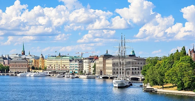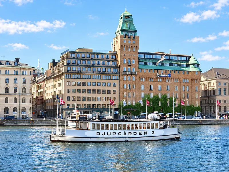
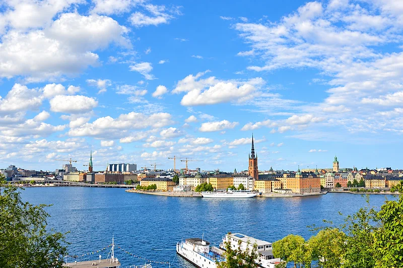
Looking for the absolute best panoramic views of the Swedish capital?
With 14 islands and endless skylines, knowing where to catch that perfect city vista isn't always obvious.
Whether you're searching for dramatic cliffside walks, iconic tower lookouts, or golden-hour sunset spots, here are the top Stockholm viewpoints you simply can't miss.
Let’s dive right in!
01 / THE STOCKHOLM GUIDE
Stockholm’s Viewpoints at a Glance
Quick Navigation: Stockholm Viewpoints by Experience
The best views in Stockholm come from four kinds of places:
At-a-Glance Vantage Breakdown
FOUR GROUNDS, ONE SKYLINE
- Vantage TypeElevation ProfilePrimary TerrainEffort LevelBridges & Waterfront PromenadesBridges & EsplanadesWater level to mid-tier archesPaved sidewalks, level waterfront flagstonesLow
Level, wide-angle water basins framing skyline silhouettes without elevation climbs.
- Vantage TypeElevation ProfilePrimary TerrainEffort LevelUrban Rooftops & Moraine HillsHilltop Parks & RooftopsRolling moraine hills & urban roofsGravel paths, park lawns, modern elevator accessLow to Moderate
Elevated neighborhood parks and modern commercial terraces overlooking inner-city street grids.
- Vantage TypeElevation ProfilePrimary TerrainEffort LevelNatural Bedrock CliffsNatural CliffsHigh natural bluffsExposed bedrock, wooden boardwalks, stone stepsModerate
High granite bluffs along southern ridges offering unobstructed, open-air panoramic vistas.
- Vantage TypeElevation ProfilePrimary TerrainEffort LevelHistoric TowersMaximum vertical heightNarrow interior brick ramps, tight spiral stairsHigh
Central architectural spires with 360-degree aerial perspectives over the historic core.
Terrain, effort and elevation words are the guide’s own. The pips simply put its four effort words in order — they are not a measured scale, and the drawing is a schematic, not a survey.
Access Overview: Free vs. Ticketed Lookouts
Planning an efficient route means knowing entry logistics before setting out:
No ticket named
Free Outdoor Public Access
Natural cliffs, bridges, waterfront esplanades, and public hilltop parks remain open year-round with zero entry fees. These locations provide complete freedom for early morning or late-night photography.
Ticket or patron access
Ticketed & Managed Venues
Historic municipal towers and commercial rooftop lookouts require seasonal ticketed entry, timed slots, or venue patron access during standard operating hours.
02 / THE STOCKHOLM GUIDE
Södermalm’s Northern Ridge: Free Viewpoints
Monteliusvägen, Skinnarviksberget and Fjällgatan, all on Södermalm’s northern cliff ridge, give free views across the historic centre, Lake Mälaren and the harbour entrance: Monteliusvägen and Skinnarviksberget for the evening light, Fjällgatan for the morning.
ONE FAULT LINE, FOUR LOOKOUTS
Order quoted from the guide’s own circuit: Skinnarviksberget · Monteliusvägen · Katarina Footbridge · Fjällgatan. Spacing is even, not to scale.
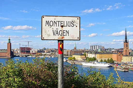
Monteliusvägen: Cliffside Boardwalk Overlook
The Monteliusvägen walking path is a 500-meter cliff-edge trail that delivers one of the most balanced framing angles in the city. From the wooden safety railings, you get a clear, elevated view directly across the Riddarfjärden panoramic overlook toward Stockholm City Hall and the copper spires of Riddarholmen and Gamla Stan.
- Vantage Highlights
- Direct sightlines to Stadshuset, Riddarholmen Church spire, and Norr Mälarstrand.
- Ground Terrain
- Level wooden boardwalk sections interspersed with packed gravel paths and short sets of wooden steps.
- Optimal Light
- Late afternoon golden hour into blue hour, when the sun lights up the red-brick facade of City Hall and the water reflects the city lights.
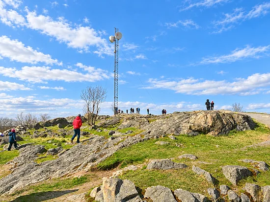
Skinnarviksberget: Stockholm’s Highest Natural Bedrock Ridge
For an open, unrestricted vantage point, head slightly further west to Skinnarviksberget. As the highest natural point in central Stockholm, this exposed granite outcrop sits roughly 53 meters above sea level and serves as the city's favorite open-air gathering spot.
- Vantage Highlights
- Broad western horizon, sweeping views of Kungsholmen, Västerbron, and the entire Riddarfjärden basin.
- Ground Terrain
- Raw, undulating granite bedrock. The surface is grippy in dry weather but requires careful foot placement on uneven crevices.
- Optimal Light
- Peak sunset. This is the premier Stockholm golden hour location to watch the sun drop behind the western waterways.
- 500 m
- Monteliusvägenof cliff-edge path
- 53 m
- Skinnarviksbergetabove sea level
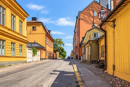
Fjällgatan & Stigbergsgatan: Historic Wooden Quarters & Harbor Vistas
On the eastern flank of the ridge, Fjällgatan and the adjacent Stigbergsgatan perch directly above the commercial waterways. This area combines historic 18th-century timber cottages with a wide maritime perspective where Lake Mälaren empties toward the archipelago.
- Vantage Highlights
- The maritime harbor (Saltsjön), Skeppsholmen, the fortress on Kastellholmen, and the green shores of Djurgården.
- Ground Terrain
- Flat stone-paved sidewalks, wide railing lookouts, and historic cobblestone lanes.
- Optimal Light
- Early morning side-light, which illuminates the waterfront facades of Gamla Stan and the incoming ferry traffic.
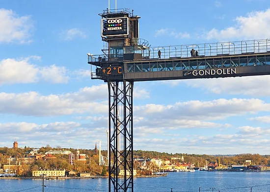
Katarina Footbridge & Mosebacketerrassen: Elevated Urban Gateways
Positioned right above Slussen, the elevated walkway connected near the Katarinahissen structure and the public square at Mosebacketerrassen offer an industrial-meets-historic urban vantage point.
- Vantage Highlights
- Direct bird’s-eye perspective over the Slussen lock system, the historic rooftops of Gamla Stan, and the open bay of Saltsjön.
- Ground Terrain
- Flat steel-mesh footbridge platforms, modern elevators, and paved square walkways.
- Optimal Light
- Dusk and early evening, providing sharp geometric angles for modern architectural and Stockholm skyline photography.
When the evening light lasts longestWalk on from the ridge into the rest of Södermalm
03 / THE STOCKHOLM GUIDE
The City Hall Tower (Ticketed)
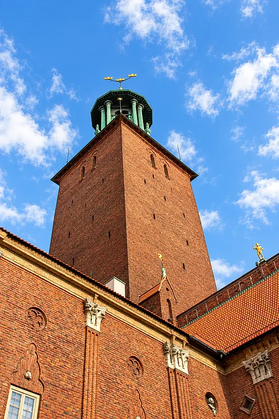
Stockholm City Hall Tower (Stadshustornet)
Stadshustornet is the highest vantage point in the middle of the city, and the view from the top runs across Riddarfjärden to the spires of Gamla Stan, the water and the ridges of Södermalm. Two things decide whether you get up there at all: the tower is a summer opening whose dates the City Hall publishes a month at a time, and the city plans to close it for restoration — the work is expected to start in early 2027 and to be finished at the end of 2028, on a timetable the city calls preliminary.
- Vantage Point
- Stadshustornet (City Hall Tower)
- Access Type
- Seasonal Ticketed Entry (Timed Slots)
- Physical Exertion
- Moderate to High (365 steps / inclined ramps)
- Optimal Light
- Morning to Midday Side-Light
- Key Visual Highlights
- Gamla Stan spires, Riddarfjärden basin, Central bridges
Physical Ascent Details: Ramps, Stairs, and Belfry
The City Hall sets out the way up in three parts:
THE CLIMB ITSELF
- Lift to the halfway point
- An elevator takes you halfway up the tower.
- The Tower museum
- At the halfway mark sits the Tower museum, with drawings and models of statues and details from the building.
- Stairs and sloping passageways
- From there to the top the climb is mainly stairs and sloped passageways, around 365 steps in all if you walk the whole tower.
- Physical exertion
- Moderate to High (365 steps / inclined ramps)
- Optimal light
- Morning to Midday Side-Light
Only the halfway mark is a figure the City Hall gives; the bands above it are drawn in the order it describes them, not in any stated proportion.
Seasonal Entry Requirements and Exertion Guidelines
What the tower asks of you. Each time slot holds 27 tickets and tickets go on sale one week ahead, so a summer afternoon can be sold out before you arrive. Strollers, large bags and other bulky objects cannot go up; there are lockers by the entrance.
Where the tower sits in a three-day routeWhat the City Hall tower asks before you climb it
04 / THE STOCKHOLM GUIDE
Step-Free Views: Bridges and Waterfronts
For views without a climb, go to Västerbron, Skeppsholmsbron and Kastellholmen, or Evert Taubes terrass on Riddarholmen.
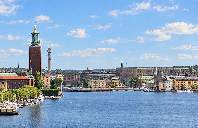
Västerbron
The High-Arch Skyline Panorama
Head to the center of Västerbron for the most expansive east-facing view over the Riddarfjärden basin. This high-arch bridge connects Kungsholmen to Södermalm, lifting you well above the water to frame the entire historic core in a single sweep.
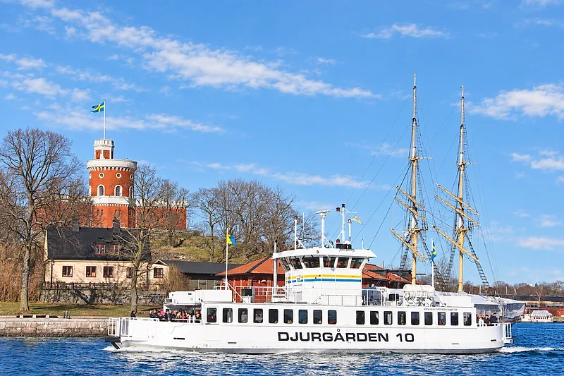
Skeppsholmsbron and Kastellholmen
Maritime Harborside Angles
Crossing Skeppsholmsbron—instantly recognizable by its cast-iron golden crowns—leads to the quiet island paths of Kastellholmen. These low-to-mid elevation maritime viewpoints place you right at the edge of the central harbor.
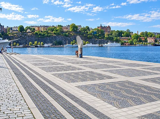
Evert Taubes Terrass
Water-Level Riddarholmen Esplanade
Located on the western tip of Riddarholmen, Evert Taubes Terrass is a broad stone promenade built right at water level. Instead of looking down on the city, this vantage point gives you an intimate perspective looking up at the dramatic natural landscape.
| Lookout | Vantage Point | Terrain & Accessibility | Best Lighting |
|---|---|---|---|
| Västerbron | Vantage Point Direct, wide-angle sightlines toward the Stockholm City Hall tower, the church spires of Riddarholmen, and the open expanse of Lake Mälaren. | Terrain & Accessibility Paved, dedicated pedestrian and bike paths. The approach is a steady, gentle incline. | Best Lighting Golden hour and late afternoon, when the western sun illuminates the red-brick towers and copper spires across the water. |
| Skeppsholmsbron and Kastellholmen | Vantage Point Clean, eye-level compositions of the Royal Palace, the grand 19th-century waterfront facades along Strandvägen, and traditional wooden sailing ships moored along the quay. | Terrain & Accessibility Flat asphalt bridge sidewalks transitioning into wide, well-maintained gravel paths on Kastellholmen. Free public access around the clock. | Best Lighting Eastern morning light highlights the pale stone of the Royal Palace, while blue hour delivers crisp reflections across the calm harbor water. |
| Evert Taubes Terrass | Vantage Point Unobstructed views directly across Riddarfjärden toward the rugged granite cliffs and wooden cottages of northern Södermalm, alongside passing archipelago ferries. | Terrain & Accessibility Wide, completely flat stone flags with a few benches. Level access directly from the Riddarholmen quayside. | Best Lighting Sunset and evening blue hour, as the sun dips directly behind the western horizon and casts long reflections across the lake. |
05 / THE STOCKHOLM GUIDE
Hilltop Parks and Rooftop Terraces
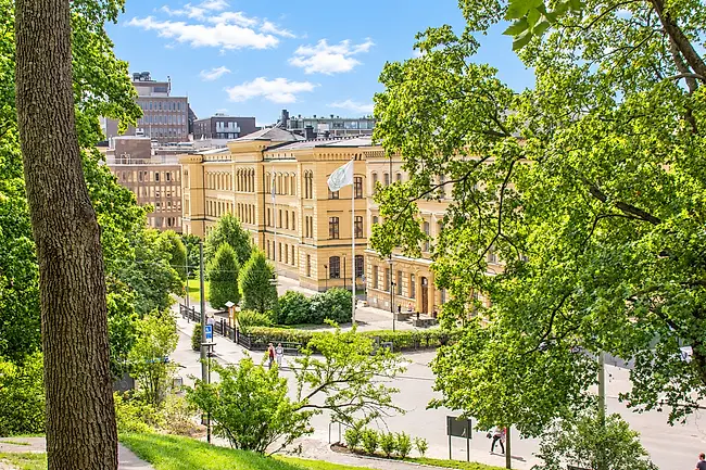
Observatorielunden
Vasastan’s Elevated Moraine Ridge
For a break from the waterfront panoramas, head up to Observatorielunden. Positioned on a steep gravel moraine ridge in the Vasastan district, this hilltop park offers an authentic look over Stockholm’s northern residential quarters and copper-domed skylines. The historic 18th-century observatory sits at the crest, providing a quiet, elevated vantage point above the bustle of Sveavägen and Drottninggatan.
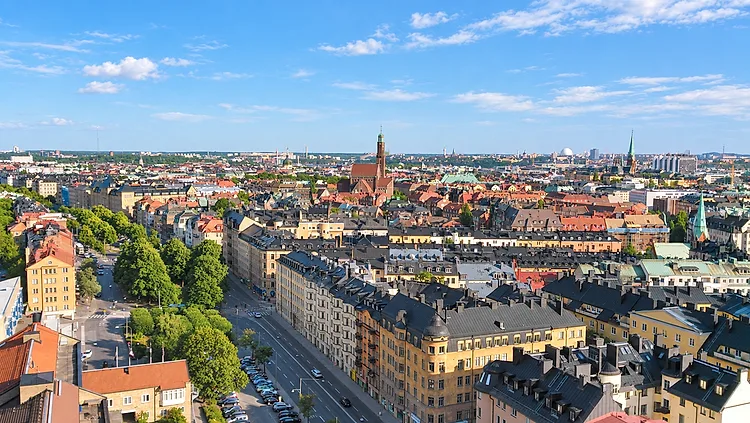
Central Urban Rooftop Terraces
Modern High-Rise Vistas in Norrmalm
For a direct look at Stockholm’s commercial core, the elevated terraces and high-rise rooftops around Norrmalm deliver a distinct architectural contrast to the natural cliff paths. These vantage points place you directly above the modernist hubs around Sergels Torg and Brunkebergstorg, letting you look down on urban transit corridors while keeping the historic spires of the Old Town visible on the southern horizon.
Terrain & Footing
Graded gravel walking paths and stone stairways traverse the park slope. The final crest around the old observatory is level, packed dirt and grassy lawn.
Terrain & Footing
Flat indoor and outdoor composite decking, smooth paved surfaces, and elevator access with full barrier-free mobility.
Vantage Point
Sweeping views looking north and east across classic Vasastan architecture, featuring distinct orange clay roof tiles, ochre residential facades, and church spires.
Vantage Point
Unobstructed lines of sight over central downtown rooftops, the high-rise towers of Hötorget, and the straight urban avenues cutting through Norrmalm.
Access Level
Free public park with open access year-round.
Access Level
Mixed access through hospitality venues, hotel rooftops, and commercial viewing terraces requiring basic patron entry or open bar access.
Photography & Lighting
Late afternoon brings warm side-lighting across the northern building facades, making it an exceptional spot to photograph urban street grids from above.
Photography & Lighting
Prime territory for blue hour photography. The combination of illuminated streets, modern glass reflections, and ambient city lights provides balanced contrast once natural daylight fades.
06 / THE STOCKHOLM GUIDE
Light, Footwear and Walking Routes
Face east in the morning and west for the evening light, wear shoes with grip on the bare rock, and in winter keep to railed boardwalks and gritted paths.
Lighting Strategy: Eastern Morning Light vs. Western Golden Hour
Stockholm’s waterways split the city into distinct visual corridors. Matching your vantage point to the sun’s angle makes a massive difference for Stockholm skyline photography:
WHEN EACH ONE WORKS
Lookout
Morning
Midday
Golden hour
Blue hour
Monteliusvägen
Skinnarviksberget
Fjällgatan & Stigbergsgatan
Katarina Footbridge
City Hall Tower
Västerbron
Skeppsholmsbron
Evert Taubes Terrass
Observatorielunden
Norrmalm rooftop terraces
Filled where the guide names that light for that lookout — in its own light note, or in the lighting strategy. An empty cell means the guide is silent, not that the view is poor.
- Morning Light (East-Facing Vistas) Head to the Fjällgatan viewpoint or Skeppsholmsbron early in the day. The rising sun lights up Gamla Stan's ochre facades and the Royal Palace without harsh backlight.
- Midday Side-Light Cross over Västerbron or stroll along Evert Taubes Terrass when the sun is high. Clear water reflections fill the Riddarfjärden basin.
- Golden Hour & Sunset (West-Facing Heights) Make your way up to Monteliusvägen walking path or Skinnarviksberget for prime sunset angles. The low evening sun sets directly behind Lake Mälaren, casting warm tones across City Hall’s brick tower and copper spires.
- Blue Hour Stick around northern Södermalm 20 to 40 minutes after sunset. The city streetlamps and illuminated bridges create high-contrast reflections across the open water.
Footwear and Physical Terrain Guidelines
The paths connecting Stockholm viewpoints vary from modern urban boardwalks to raw, uneven rock:
WHAT IS UNDERFOOT
- Exposed Granite Bedrock Found extensively at Skinnarviksberget. The bare stone is slick when wet and uneven underfoot. Wear shoes with deep rubber tread or trail soles.
- Wooden Boardwalks & Planks The Monteliusvägen path features level timber walkways with guardrails. Flat walking shoes or standard sneakers work well here.
- Cobblestones & Historic Stone Steps Access routes climbing out of Slussen toward Katarinahissen and high Södermalm feature steep, polished cobblestones. Avoid slick leather soles or thin heels.
Surfaces and footwear advice quoted from the guide. Patterns are illustrative.
Seasonal Terrain Hazards and Daylight Shifts
Stockholm’s northern latitude brings massive shifts in lighting and walking conditions throughout the year:
- Winter Ice on Natural Ridges Municipal services grit main sidewalks, but exposed bedrock bluffs like Skinnarviksberget remain ungritted. Black ice forms easily on open stone ledges. Pack slip-on microspikes if visiting during sub-zero stretches.
- Sub-Zero Daylight Compression In midwinter, daylight lasts about six hours. The sun never climbs high, giving you an extended low-angle golden hour all midday, but platforms turn dark rapidly by mid-afternoon.
- Summer Light Around midsummer the sun is up for over 18 hours, and twilight lingers late into the evening, leaving time for the ridge viewpoints after dinner.
Curated Scenic Walking Circuits
Combine multiple free viewpoints in Stockholm using these two streamlined walking routes:
TWO WAYS TO STRING THEM TOGETHER
Distance Approximately 4 km (2.5 miles)
Route
- Skinnarviksberget
- Monteliusvägen
- Katarina Footbridge
- Fjällgatan
Terrain Natural rock, wooden boardwalks, paved historic streets
Highlights Panoramic views over Riddarfjärden, Riddarholmen, and the central maritime harbor.
Distance Approximately 3.5 km (2.2 miles)
Route
- Stockholm City Hall esplanade
- Centralbron footway
- Riddarholmen
- Skeppsholmsbron
- Kastellholmen
Terrain Paved sidewalks, flat bridges, level stone quays
Highlights Low-elevation water-level perspectives framing the Södermalm cliffs, Gamla Stan waterfront, and historic naval docks.
Only the totals are to scale; the guide gives no leg distances, so the stops are listed in its order rather than placed along the rule.
07 / THE STOCKHOLM GUIDE
Frequently Asked Questions About Stockholm Viewpoints
What is the single best free view of the Stockholm skyline?
One cliff path and one bare ridge, both open ground.
For an iconic, postcard-perfect panorama, Monteliusvägen takes the top spot. This narrow footbridge and cliffside path on Södermalm sits directly across Riddarfjärden, framing the Stockholm City Hall, Riddarholmen Church spires, and Gamla Stan without costing a single krona. If you prefer an open, natural vantage point on bare red granite bedrock, the nearby Skinnarviksberget offers the best wide-angle, panoramic skyline view in the city.
Which Stockholm viewpoints are accessible without climbing steep stairs or rocks?
Four lookouts the guide describes as level or lift-served.
If you want scenic overlooks with zero stair-climbing or rough terrain, several prime waterfront locations offer level, paved access:
- Västerbron Bridge
- Features wide, paved sidewalks with a continuous, gentle incline across the Riddarfjärden basin.
- Skeppsholmsbron & Kastellholmen
- Completely flat street-level walking paths with open maritime angles toward the Royal Palace and Strandvägen.
- Evert Taubes Terrass
- A flat, stone-paved esplanade on the western tip of Riddarholmen looking straight across at the Södermalm cliffs.
- Katarina Footbridge
- Accessible directly via public elevators from the Slussen transit hub, bypassing the steep hillside stairs entirely.
Are natural viewpoints like Skinnarviksberget safe during winter or rain?
Bare rock is the exception: it is neither gritted nor cleared.
Exposed granite bedrock becomes extremely slick when wet, and dangerous during freezing winter conditions when ice sheets form over the slopes. Natural rock viewpoints like Skinnarviksberget are not gritted or cleared of snow by municipal teams. In wet weather or freezing months, stick to the railed wooden boardwalks and gritted gravel paths along Monteliusvägen or the paved overlook at Fjällgatan. If you visit bare rock ridges in winter, wear sturdy footwear equipped with slip-resistant rubber treads or ice grips.
Do I need to book tickets in advance for the Stockholm City Hall Tower?
The guide points you at the official page for the current terms.
Not strictly: tickets can also be bought on the day at the City Hall ticket office, subject to availability. Each ascent has limited capacity, so booking ahead is the safer plan during busy periods. Check the official tower page for current dates, tickets and access details. The city also has a restoration of the tower in planning, and says the tower will be shut to visitors while that work runs; its project page carries the dates.
Where are the best spots in Stockholm for golden hour and sunset photography?
The western water is where the guide sends you at the end of the day.
Stockholm's topography offers exceptional evening light across its western-facing waterways:
- Skinnarviksberget
- Stockholm’s premier sunset spot, where low-angled western light illuminates the water basin and silhouettes the central city spires.
- Monteliusvägen
- Delivers warm, direct golden hour side-lighting across the red brick facade of City Hall and the ochre buildings of Gamla Stan.
- Västerbron
- High-arch elevation provides unobstructed sunset perspectives looking east across the full breadth of central Stockholm.
- Fjällgatan
- Positioned eastward on Södermalm's ridge, making it ideal for catching the lingering pink and purple hues of the blue hour over Saltsjön harbor and Djurgården.
08 / FURTHER READING
Related Sources
BEFORE YOU GO
A flexible plan is a better plan.
Opening hours, admission policies, services and access can change. Check each attraction’s official website and the SL journey planner before travelling. Suggested times in this guide are planning estimates, not venue opening hours or guaranteed transfer times.
Last verified .
PHOTOGRAPHS & LICENCES11
- Blick auf Riddarholmen.jpg — Olaf Meister · CC BY-SA 4.0, via Wikimedia Commons. Brightened and colour-adjusted for this page; cropped to fit. The edited version is shared under the same licence.
- Montelisvägen 2009.JPG — Holger.Ellgaard · CC BY-SA 3.0, via Wikimedia Commons. Brightened and colour-adjusted for this page; cropped to fit. The edited version is shared under the same licence.
- Skinnarviksberget.jpg — Esquilo · CC BY-SA 3.0, via Wikimedia Commons. Brightened and colour-adjusted for this page; cropped to fit. The edited version is shared under the same licence.
- Summer in Stockholm - Fjällgatan, Södermalm (Sweden) - panoramio.jpg — Tommie Hansen · CC BY 3.0, via Wikimedia Commons. Brightened and colour-adjusted for this page; cropped to fit.
- Katarinahissen nov 2013a.jpg — Holger.Ellgaard · CC BY-SA 3.0, via Wikimedia Commons. Brightened and colour-adjusted for this page; cropped to fit. The edited version is shared under the same licence.
- At Stockholm 2019 024.jpg — Photograph by Mike Peel (www.mikepeel.net). · CC BY-SA 4.0, via Wikimedia Commons. Brightened and colour-adjusted for this page; cropped to fit. The edited version is shared under the same licence.
- Stockholm 2009 PD 229.JPG — Bin im Garten · CC BY-SA 3.0, via Wikimedia Commons. Brightened and colour-adjusted for this page; cropped to fit. The edited version is shared under the same licence.
- Djurgården 10, Kastellholmen.jpg — AleWi · CC BY-SA 4.0, via Wikimedia Commons. Brightened and colour-adjusted for this page; cropped to fit. The edited version is shared under the same licence.
- Evert Taubes terrass, Stockholm, Sweden.jpg — Jim G · CC BY 2.0, via Wikimedia Commons. Brightened and colour-adjusted for this page; cropped to fit.
- At Stockholm 2019 278.jpg — Photograph by Mike Peel (www.mikepeel.net). · CC BY-SA 4.0, via Wikimedia Commons. Brightened and colour-adjusted for this page; cropped to fit. The edited version is shared under the same licence.
- Nyponet view, 2014.jpg — FireyFly · CC BY-SA 4.0, via Wikimedia Commons. Brightened and colour-adjusted for this page; cropped to fit. The edited version is shared under the same licence.